Mission
A “European GPS”
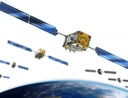
Since 1998, the European Union has decided to acquire its own independent global positioning system to meet growing demand for satellite navigation services. Through the European Space Agency (ESA), which has been managing the technical side of the programme since 2003, Europe has within the space a decade put together the required building blocks and since 2011 started deploying the first satellites of the Galileo programme alongside an extensive infrastructure of ground stations. The active constellation, capable of delivering unrivalled positioning accuracy on the order of one metre, already has more than 100 million users and is ramping up for full operational service in 2020-2022. Ultimately, Galileo will boast a network of 24 operational satellites and on-orbit spares.
The constellation is controlled by GSA, the European GNSS1 Agency, since 1 January 2017.
The Galileo positioning system officially entered service on 15 December 2016 with 18 satellites in orbit. Each satellite in the constellation continuously emits its identity and the timing signal from its internal atomic clock. When this information is received by a compatible chip, for example in a smartphone, it is triangulated: if the device is able to receive messages from at least four satellites, its chip calculates a precise position in three dimensions. This process is complemented by referencing tables that allow chips to infer the theoretical position of a satellite with respect to the others in the constellation. Lastly, the satellites communicate with the two Galileo ground stations to calibrate their atomic clocks, confirm their exact position and rectify their orbit if needed.
1 Global Navigation Satellite Systems
Space component
Two satellites, GIOVE-A and GIOVE-B (for Galileo In-Orbit Validation Element), were orbited in 2005 and 2008 to validate the required technologies.
In 2011 and 2012, four In Orbit Validation (IOV) satellites were then sent into space, prefiguring the final Galileo system: their atomic clocks, orbit, launch and constituent systems served to validate the operational Galileo constellation. With these four satellites, teams successfully conducted the first positioning tests in the Netherlands in the spring of 2013. Deployment of the constellation could now begin and the IOV satellites were integrated into the final system. Since 2014, the 22 Full Operational Capability (FOC) satellites have been launched at a sustained pace.
Ground segment
A global positioning system like Galileo couldn’t work without a full network of coordinated ground stations. Some of these stations directly control the satellites—the Galileo Control Centres (GCC) and the Telemetry, Tracking and Control (TT&C) centres—while others assess and correct the positioning system’s performance—the Galileo Sensor Stations (GSS) and the network of Uplink Stations (ULS).
Galileo services
Galileo is the only constellation to offer four different services:
- Open Service, through which any user equipped with a compatible antenna and chip will be able to receive positioning data. This is the signal designed for consumer applications.
- An enhanced service (initially designed to be a commercial pay service) combining other frequencies to add value through authentication and 10-metre positioning for the general public—a service unequalled anywhere in the world.
- Public Regulated Service (PRS), designed for Galileo partner governments within the European Union, for critical public services. This service is not open to the public and provides extra encryption.
- Search and Rescue (SAR) service, Europe’s contribution to the global Cospas-Sarsat system for detecting and locating emergency beacons.