CNES projects library
C
I
M
P
S
U
Bi
Galileo
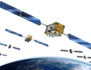
The Galileo programme was decided at the start of the 2000s to assure Europe’s independence in the field of GNSS (Global Navigation Satellite System). The European system would be based on a constellation of 30 satellites—24 nominal satellites and six in-orbit spares—operating alongside the U.S. GPS, Russian Glonass and Chinese Beidou systems.
Launched in tandem in 2011 and 2012, the first four Galileo satellites validated the new geopositioning system. Initial Galileo services came on stream in December 2016, with 15 operational satellites. The satellites were orbited by seven Soyuz launchers (dual launches) and an Ariane 5 launch (four satellites) from the Guiana Space Centre. From early 2017 to early 2022, one satellite was taken out of service for maintenance and three new satellites were orbited, with two launches by Ariane 5 and one by Soyuz, taking the constellation to 24 operational satellites. Future Galileo launches will all be accomplished by Ariane 6 from 2024. Full Operational Capability (FOC) of the open service will be declared after the next two launches, which will complete the constellation.
Galileo will support a broad range of applications in domains such as maritime, air and land transport, agriculture, public works, search-and-rescue operations and government, as well as applications that we use in our daily lives, notably on our smartphones. It’s estimated that more than 2.4 billion smartphones now have a Galileo receiver (January 2022). They are interoperable and obtain a single positional fix using the four available constellations. Galileo today offers users the best positioning service there is with a horizontal accuracy of one metre. In the near future, it will also offer a High Accuracy Service (HAS)—accurate to 20 centimetres with a convergence time of a few minutes—and signal authentication to combat spoofing.
CNES was closely involved in the preliminary phases of Galileo and in defining its signals, and the agency’s Space Transportation Directorate contributed to the Ariane 5 ES and Ariane 6 launchers’ qualification. Its Toulouse Space Centre was involved in planning and conducting satellite positioning operations in partnership with the European Space Operations Centre (ESOC), as part of ‘CNESSOC’ up to 2018. CNES is currently helping to assess Galileo performance within a consortium working for EUSPA and operates the Galileo Search and Rescue (SAR) service centre that collects and transmits alerts from emergency locator beacons all over the world, relayed by the Galileo satellites’ SAR payloads.
Mission's news feed
-

[CNESMAG] Galileo:a constellation of services
Our new issue is now available !
May 18, 2022
-
[Live] Follow Soyouz/Galileo launch on December 4-5, 2021
For its 13th launch of the year, Arianespace orbited two more satellites Galileo: FOC 23 and 24 from our Guiana space center.
December 4, 2021
-
Galileo satellites’ last step before launch
Europe’s Galileo satellite navigation constellation is set to grow. Later this year the first two out of 12 ‘Batch 3’ Galileo satellites will be launched by Soyuz from French...
June 3, 2021